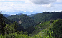
 The Leech Water Supply Area (WSA) consists of 92 % of the watershed area of the Leech River above the existing tunnel that will be used to divert water to Sooke Lake Reservoir. Based on current water use, it is estimated that it will be several decades before water from the Leech WSA is needed to supplement water storage in Sooke Lake Reservoir.
Many projects and assessments are underway to enhance the restoration of the area for water supply and to improve water quality.
The Leech WSA receives more rainfall and snow than the Sooke and Goldstream Water Supply Areas. The elevation ranges from approximately 200 metres above mean sea level (AMSL) near the intake of the Leech River tunnel to 941 m at the summit of Survey Mountain. The northern portion of the Leech WSA consists of a high elevation plateau with three lakes and numerous wetlands. The main stem rivers (West Leech, Leech, and Craig Creek) flow along deeply incised river valleys toward the south and eventually into Sooke River.
Prior to purchase by the CRD, the lands within the Leech WSA were owned by forest companies that harvested about 95% of the area. An extensive network of more than 400 km of roads was constructed during forest harvesting. All harvested areas were planted with native tree species and are regenerating well. The CRD is undertaking an extensive watershed restoration program to prepare for future water supply needs.